| New Products & Service | Simulation |
|
3D real-time VR software package that supports consensus building in road and public works projects | |
●Price
Ultimate:USD17,200
Driving Sim:USD11,000
Advanced:USD8,800
Standard:USD6,000
CIM Lite:USD4,800
●ReleaseDecember 2023
Improvement of Terrain Editing
In UC-win/Road Ver.17.1, the terrain editing function has been improved and terrain editing in the 3D scene has been made easier. This makes it easier to eliminate overlapping cuttings that occur between roads, or to edit detailed terrain to match road grades.
To edit terrain patch to express detailed terrain, we can edit it on the terrain patch editing screen or change the elevation by selecting terrain patches in the 3D scene.
The terrain editing on the 3D scene has been expanded and users can select a zone and elevation point to edit the terrain.
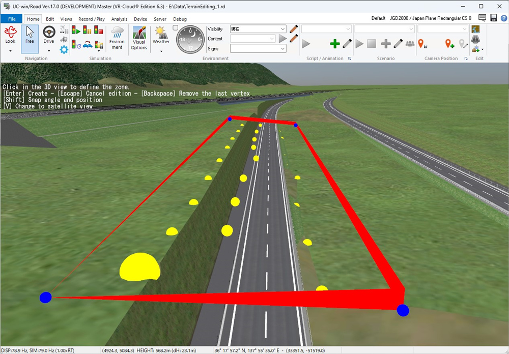
Fig.1 Elevation zone selection
By clicking and dragging the terrain, you can select all the elevation points within tit. This feature allows you to select not only the elevation points of the terrain patch, but also the elevation points of the terrain grid. You can change the height of selected elevation points all at once by mouse dragging or entering numerical values. In addition, the elevation points of terrain patches can be moved in the plane direction by dragging mouse, which was not possible before.
In Ver.17.1 you can now add or delete elevation points for terrain patches on a 3D scene by clicking, which was only possible on the terrain patch editing screen in the previous version. if you want to edit the terrain according to the road, you can add elevation points to match the display of the road slope in the 3D scene.
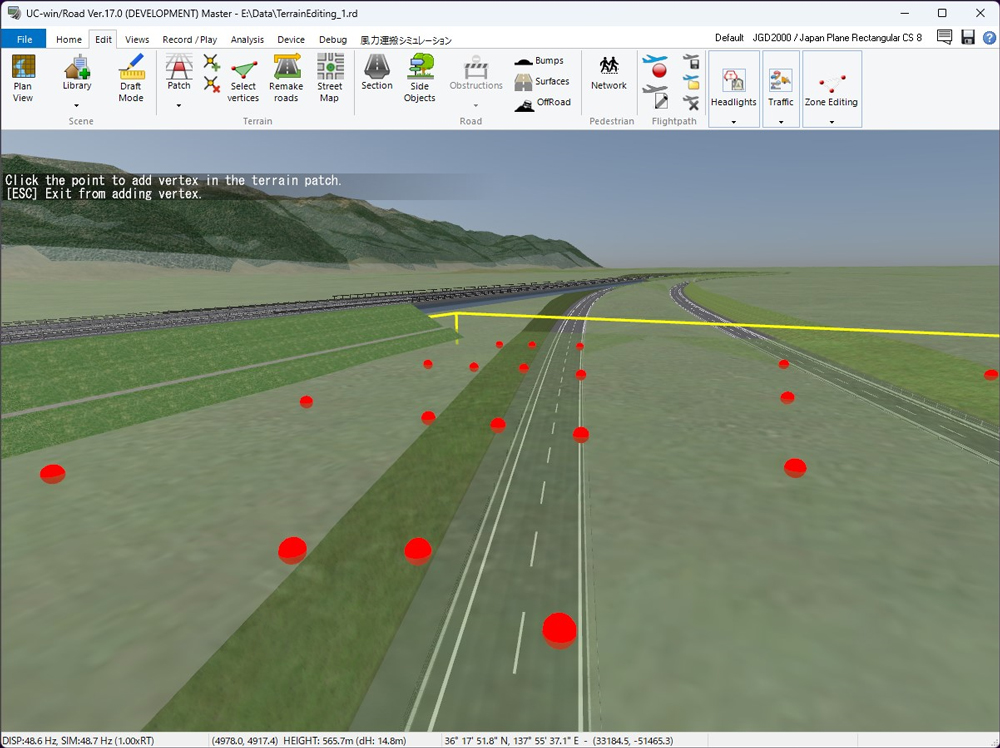
Fig.2 Add terrain point on the 3D scene
After editing the terrain, you can call the road regeneration process from the ribbon menu without opening the plan view. Roads are regenerated without unnecessary processing, which reduces the waiting time compared to the road regeneration process performed in the plan view.
These improvements to the terrain editing functions in Ver.17.1 make it easier to edit detailed terrain in areas with multiple roads and to check the results. As a result, you can expect to spend less time creating the current situation than ever before.
Improved SDK Functions (C++, Python)
You can now edit the HUD (Virtual Display) Plug-in and Quest Rift Plug-in using the C++ API and Python API.
For the HUD, it will be possible to add/delete, show/hide virtual displays, control various setting information, and implement virtual display drawing processing using OpenGL. Regarding Quest Rift, acquisition of HMD status (Quest model, HMD posture, tracking status) and HMD drawing detailed information (viewing angle, eye deviation from HMD), scene drawing in OpenGL, implementation of HUD drawing processing will be possible.
HUD (Virtual Display) used in HUD R&D and education and training systems for construction machinery, automobiles, etc. allows users to draw free shapes and images using user-created programs. It is possible to build a HUD system that is completely synchronized with the simulation by acquiring UC-win/Road simulation information and performing condition determination. It is highly flexible as it allows free drawing of images and OpenGL from the program, allowing advanced HUD simulation and consideration.
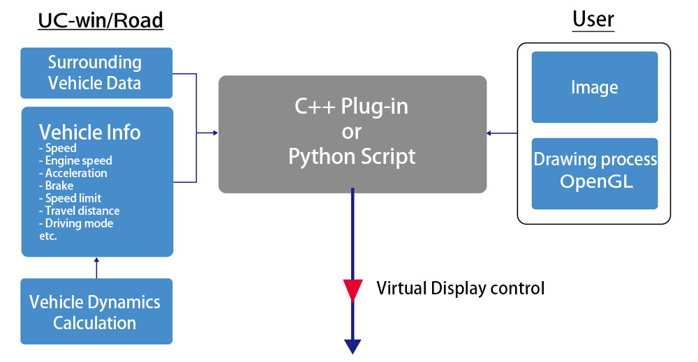
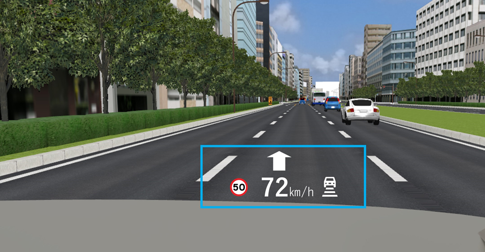
Fig.3 Example of HUD drawing using HUD virtual display control (HUD, meter panel)
| (Up&Coming '24 New Year issue) |
|
|


LOADING