| New Products & Service | Simulation |
|
F8VPS Point Cloud Functions Can also be used for planning, inspection, and maintenance management of metaverse application projects | |
●Price
JPY5,000
●ReleaseDecember 2023
| F8VPS Experience Seminar | |||
|
Overview
The use of point clouds is increasing for the study, design, and maintenance of various infrastructure-related construction projects, as well as for preliminary surveys of various sites, not just infrastructure, and for information management and current condition recording. As a digital twin, the current situation in a large area is managed using point cloud data, and the point cloud is used directly for various studies, plans, and situational understanding without 3D modeling. As the availability of open point cloud data continues to grow, there is a need for solutions that enable easy access and use of this point cloud data.
With F8VPS, it is now possible to display large point cloud data from a smartphone to a web browser on a desktop computer, and we have also added the ability to switch the display method of point cloud data and measure by selecting points on the point cloud. We will introduce each function below.
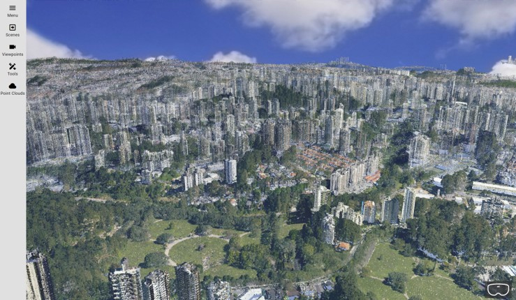
Fig.1 São Paulo open data (31,730,000,000 points)
Measurement Function
The point cloud display allows you to check the current situation as 3D spatial data without creating a 3D model. However, we have implemented a measurement function on point clouds in case you need to understand the situation quantitatively, not just visually.
The basic concept of this function is to enable accurately reference the actual point coordinates in point cloud data and perform various measurement processes. This method allows you to obtain accurate measurement information even in quantitative web applications. Also, since it is difficult to click exactly on the displayed point, we have implemented a "snap to point" function to assist in the operation.
Specifically, the following items can be measured.
(1) Point coordinates
(2) Straight line distance, height difference, plane distance between two points
(3) Length of polyline
(4) Polygon area on the horizontal plane or approximate plane
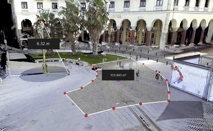
Fig.2 Example of two-point measurement and area measurement
Switch Display Method
Point cloud data often includes color information (R, G, B) or reflection intensity information (grayscale display), but by including further classification information, it is possible to add elements to the points by type, such as buildings, trees, vehicles, and road surfaces. You can view and toggle this information on the F8VPS.
A function to visualize the height (elevation) of a point using a color gradient is also provided. Especially when it is difficult to understand the normal displayed altitude over a wide area, the gradient display allows you to check high ground and skyscrapers at a glance.

Fig.3 Example of elevation data gradient display
Streaming Technology
This time, we considered two factors - device performance and data capacity - to make point cloud data usable in different usage environments. It is now possible to view tens of billions of large-scale point clouds on smartphones and tablets.
This was achieved by managing all point cloud data on the server and dynamically streaming the minimum necessary information to the client terminal according to the user's operations.
Specifically, the server sends data with a point density that matches the range of the 3D space displayed on the user terminal and the distance from the display viewpoint. Data is sent compressed in LAZ format and then decompressed on the client side using the latest high-speed processing web technology.
The number of points that can be displayed simultaneously varies depending on the display performance of the user's terminal. It is possible to adjust the number and the size of points displayed on the screen according to the environment.
By moving the viewpoint closer to the area you want to focus on, the point density of the original data is displayed as it is, and since point clouds can be displayed like a lossless format for images, accurate confirmation work using point clouds is also possible.
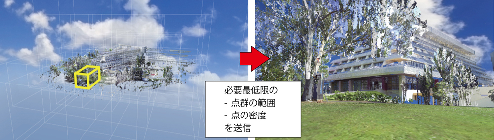
Fig.4 Partial data transfer concept
Point Cloud Data Format Support
This function is realized by managing data on the F8VPS server side in a format that is processed for distribution. Data can be processed from LAS, LAZ of original data and various formats of text data.
In the future, we will develop a way to more seamlessly store point cloud data from a scanning terminal or a machine that prepares point cloud data to the F8VPS server.
| (Up&Coming '24 New Year issue) |
|
|

